About Avare
** Not a Map app - Aviation Only. ** ** Aviation U.S. FAA materials and more. ** ** No support in Reviews. ** ** Please use our Friendly, helpful Support Forum. ** 24/7 at:...
** Not a Map app - Aviation Only. **
** Aviation U.S. FAA materials and more. **
** No support in Reviews. **
** Please use our Friendly, helpful Support Forum. **
24/7 at: https://groups.google.com/forum/#!forum/apps4av-forum
**NOTE: Avare can't function fully until you turn on BOTH
of Avare's requested Permissions (Location & Storage).
Avare (pronounced "ah vAir" - like "aware" with a "v") is a free moving-map Aviation GPS & EFB app.
*Note: Internet access is required only for installing the free app, aviation Database, and at least 1 of the free charts; and for any updates. We recommend that you TURN OFF Play Store AUTOMATIC UPDATE for Avare, manually update it and all Downloads, then fly in Airplane Mode to save battery.
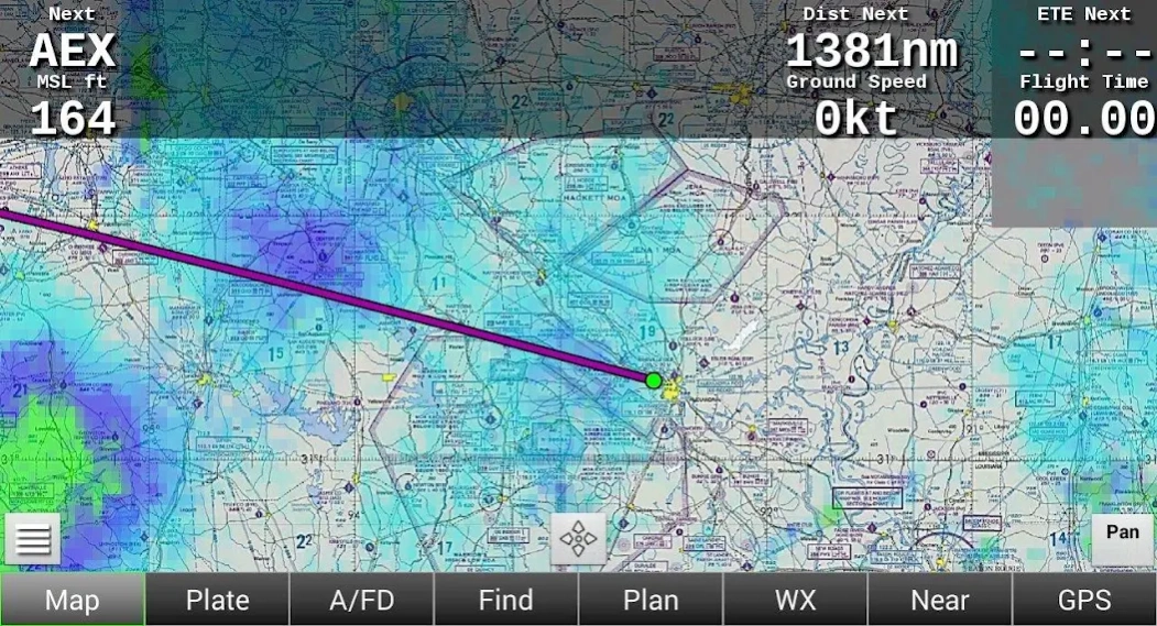
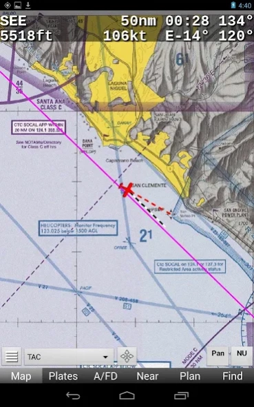
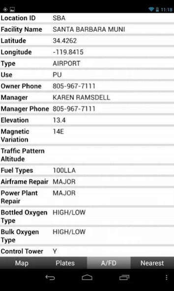
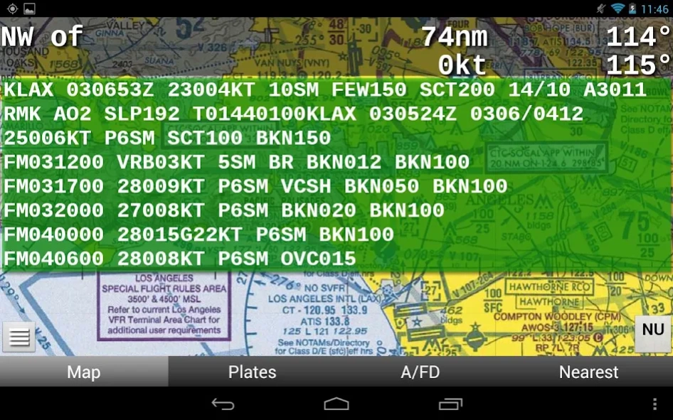
Avare offers offline moving map on all FAA charts (VFR Sectional, IFR lo/hi enroute, Approach Plate, WAC & TAC); plus A/FD info, Airport Diagrams w/GPS Taxi, and Terminal Procedures. Also: GPS status, Terrain/Elevation Maps, 50 Nearest airports, Obstacles, and more. Some FAA Charts cover Puerto Rico, plus parts of Canada, Mexico and the Caribbean. All of this is Completely Free with no ads.
*Note: Like all apps for portable devices, Avare is not FAA certified for primary navigation but may be used as outlined in FAA documents. See our NOTICE below, and the FAQ on our website for links to FAA documents.
Avare Advantages:
•Made by & for pilots
•Easy to learn & use
•Quick & responsive
•All free FAA materials & more
•Runs on most Android devices
•No ads or invasive permissions
More Features:
•Type in any address or coordinates.
•NOTAMS, METAR, TAF and Winds (Internet fetch or ADSB).
•ADSB TIS-B Traffic (UAT/1090), PIREP (free AddOn apps).
•Graphic & text TFRs (Internet fetch or ADSB).
•Canada topo, plus terrain maps for most of the world.
•External GPS, autopilot and flite sim options.
•Obstacles: Any over 500' AGL within 200' of GPS altitude.
•Frequencies, runways, fuel availability, & all A/FD info.
•13000+ GeoReferenced approach plates and taxi diagrams.
•Landscape/Portrait, North Up/Track Up (NU/TU) display.
•Draw notes on-screen, or Pan freely on charts (Draw/Pan).
•Long-Press any two points for approximate distance.
•Location icon Center, or track from your own placement.
•GPS compass direction, Bearing, and Distance to and FROM any point on the map by long-pressing one finger on that point. Great for your ATC and CTAF radio calls.
Avare installation begins with the small app, and then fetching an aviation Database and at least one chart. You can of course choose additional charts and materials for Avare to Download free at any time.
Note: The FAA occasionally changes their charts such that outdated charts may incorrectly display your location in Avare, so be sure to Update any charts you may use in flight! ANY time you plan to Update a chart, first ensure that you have the latest version of Avare and its Database.
After installing Avare, please use the Help feature to begin. New features are being added very quickly in response to user feedback, and may not be reflected in this Description page. You are invited to Contact us directly via our apps4av google group Forum to share your questions, feedback, and feature requests.
Launch Note: To access Help in the Avare app, on the Map screen tap the round Menu button, then the rectangular Help button at lower-left.
NOTICE: This software is provided "as is" and any express or implied warranties, including, but not limited to, implied warranties of merchantability and fitness for a particular purpose are disclaimed. In no event shall the copyright holder or contributors be liable for any direct, indirect, incidental, special, exemplary, or consequential damages (including, but not limited to loss of use or data) however caused and on any theory of liability, whether in contract, strict liability, or tort (including negligence or otherwise) arising in any way out of the use of this software, even if advised of the possibility of such damage.
Previous Versions
Here you can find the changelog of Avare since it was posted on our website on 2014-06-13 03:21:45.
The latest version is 10.3.1 and it was updated on 2024-04-23 09:55:04. See below the changes in each version.
Avare version 10.3.1
Updated At: 2023-11-18
Changes: Fixed FAA weather location changes
Ability to import/export ADSB recorded files
Increased map area size to reduce black borders in track up mode
Can start camera by pressing the volume button
SUAs show when pressed on map away from airports
Avare version 10.3.0
Updated At: 2023-06-24
Changes: Fixed plan filing.
Avare version 10.2.8
Updated At: 2023-06-04
Changes: Added autopilot via USB
Avare version 10.2.9
Updated At: 2023-06-04
Changes: Multi-aircraft support, moved W&B and Lists to Acft tab, along with multiple aircraft.
Avare version 10.1.4
Updated At: 2022-05-14
Changes: Bluetooth permission fix.
Avare version 10.1.2
Updated At: 2022-05-07
Changes: Fix to Bluetooth autopilot
Added tracks and user data delete function under IO tab
Tracks can be exported via email
Bigger destination dialog
Bug fixes
Avare version 10.1.1
Updated At: 2022-03-19
Changes: Bug fixes.
Import/Export of data moved to IO tab. See Help.
Import/Export of data made modular/fast.
Added Portland TAC; available in cycle 2203.
Avare version 10.0.8
Updated At: 2022-02-23
Changes: Stop bug fix
Memory optimization of shape file
Avare version 10.0.7
Updated At: 2021-09-26
Changes: (Near) now works without glide ring enabled
Fix of stop bugs
Added a chart guide
Removed cell tower based location
Avare version 10.0.6
Updated At: 2021-04-25
Changes: Plans can be deleted.